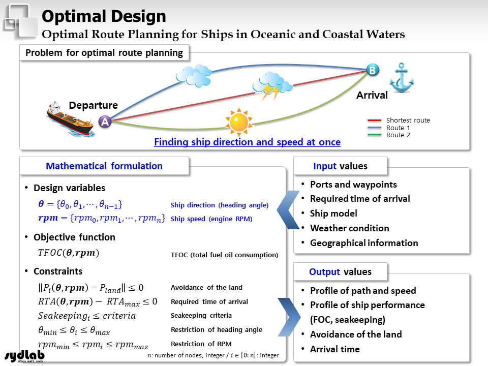
우리는 대양 및 연안 운항 선박의 최적 항로 계획 방법을 연구하고 있습니다. 제안된 방법은 대형 조선소 등의 상용 솔루션에 탑재되어 그 성능을 입증했습니다.
– 해기상 데이터의 획득, 전처리 및 저장 – 해기상 상태에 따른 선박의 성능 (부가 저항, 속도 저하) 및 연료 소모량 예측 – 전자 해도를 활용한 해안선, 해상 객체, 수심 정보 활용 – 과거 AIS (Automatic Identification System) 데이터 활용 – 빠른 계산이 가능한 항로 탐색 알고리즘 – 최적 항로 계획 문제의 정식화 (진행 방향과 속도 동시 고려)와 최적화 알고리즘
We are studying a method for optimal route planning for ships operating in oceanic and coastal waters. The proposed method has been integrated into commercial solutions, including those used by major shipyards, and has demonstrated its performance.
– Acquisition, preprocessing, and storage of weather data – Prediction of ship performance (added resistance, speed reduction) and fuel consumption based on weather conditions – Utilization of coastline, maritime objects, and bathymetric information via electronic nautical charts – Utilization of historical AIS (Automatic Identification System) data – Route finding algorithms capable of rapid computation – Formulation of the optimal route planning problem (simultaneously considering direction and speed) and optimization algorithms
해상 장애물 탐지/위치 예측/추적 (Detection, Localization, and Tracking)
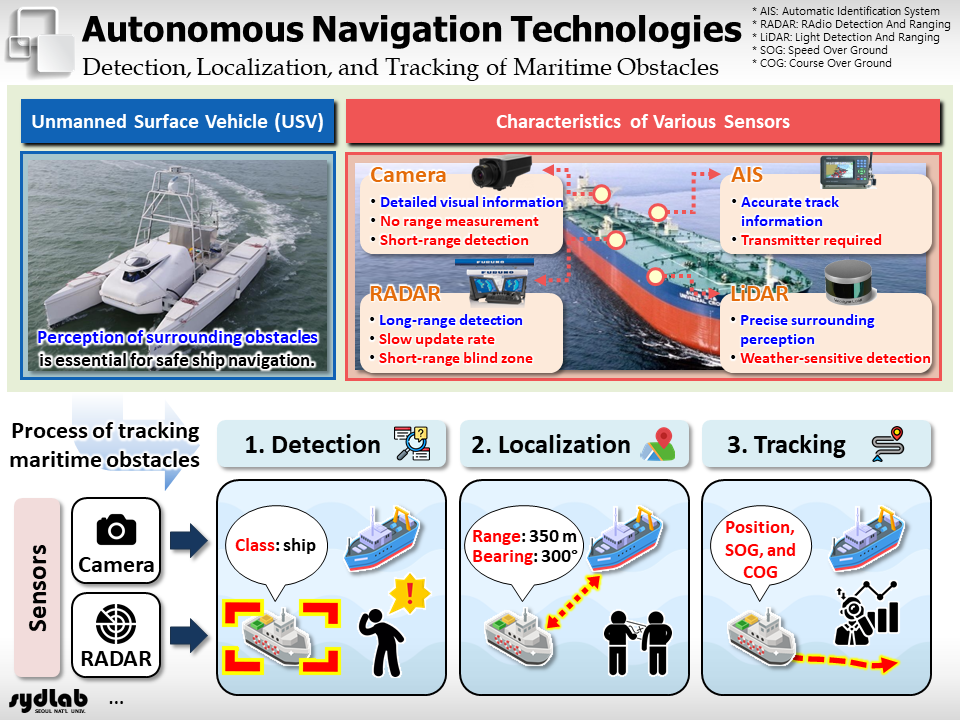
우리는 다양한 센서를 활용해 선박 주변의 해상 상황 인식을 위한 기술을 연구하고 있습니다. 이는 카메라, 레이다, AIS (Automatic Identification Systen) 등을 활용한 해상 장애물의 탐지, 위치 예측, 추적 등의 기술을 포함하고 있습니다.
– 해상 장애물 탐지 – 해상 장애물 위치 예측 – 해상 장애물 추적
We are studying various methods for recognizing maritime situational awareness around ships using various sensors. This includes methods for detecting, localizing, and tracking maritime obstacles using cameras, RADAR, LIDAR, and AIS (Automatic Identification System).
– Detection of maritime obstacles – Localization of maritime obstacles – Tracking of maritime obstacles
다중 센서 융합 (Multi-sensor Fusion)
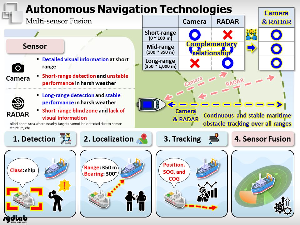
우리는 해상 상황 인식을 위한 다중 센서 (카메라, 레이다, 라이다, AIS 등)의 멀티 모달 센서 융합 방법을 연구하고 있습니다.
– 딥 러닝 모델 학습을 위한 가상 센서 데이터 생성 – 다중 및 멀티 모달 센서 융합 알고리즘
We are studying multi-modal sensor fusion methods using multiple sensors (cameras, RADAR, LiDAR, AIS, etc.) for maritime situational awareness.
– Generation of virtual sensor data for training deep learning models – Multi-sensor and multi-modal sensor fusion algorithms
선박 충돌 회피 (Ship Collision Avoidance)
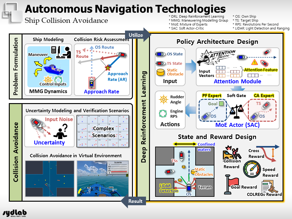
우리는 운항 시 해상 정적/동적 장애물과의 충돌을 방지하기 위한 충돌 회피 방법을 연구하고 있습니다. 해상 상황에 대한 선박 충돌 위험도 산정, 규칙 기반 및 딥 러닝 기반 (강화 학습)의 충돌 회피 경로 생성 등의 연구를 수행하고 있습니다.
– 센서 정보의 불확실성 반영 – 선박 충돌 위험도 산정 – 선박 충돌 회피 경로 생성 – 강화 학습을 위한 조우 상황 자동 생성 – 동적/정적 장애물 및 협수로 고려
We are studying collision avoidance methods to prevent collisions with static and dynamic obstacles at sea during ship operations. We are studying how to calculate collision risks based on maritime conditions and to generate collision-avoidance paths using both rule-based and deep-learning (reinforcement learning) approaches.
– Accounting for uncertainty in sensor data – Calculating collision risk – Generating collision avoidance paths – Automatically generating encounter scenarios for reinforcement learning – Accounting for dynamic/static obstacles and narrow waterways
선박 자동 접안 (Ship Automatic Berthing)
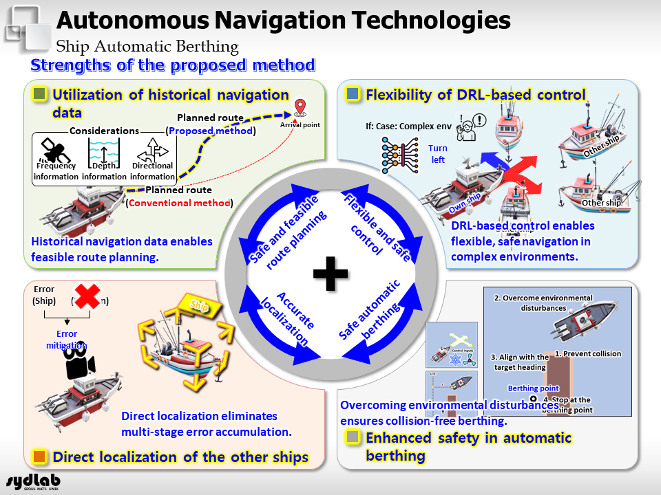
우리는 복잡한 안벽에 선박을 자동으로 접안시키기 위한 방법을 연구하고 있습니다. 즉, 소형선 및 대형선의 추진 체계를 고려하고 해상 장애물 및 안벽과의 충돌을 방지하면서 목표 지점에 정확하게 접안할 수 있는 방법을 연구하고 있습니다.
– 자동 접안을 위한 경로 생성 – 해상 장애물 및 안벽과의 충돌 방지 – 접안 방향을 고려한 강화 학습 기반의 자동 접안
We are studying methods for automatically berthing ships at complex quays. Specifically, we are studying methods that account for the propulsion systems of both small and large ships and enable them to berth accurately at their target locations while avoiding collisions with maritime obstacles and the quay.
– Path planning for automatic berthing – Collision avoidance with maritime obstacles and the quay – Reinforcement learning-based automatic berthing that accounts for berthing orientation
선박 자율 운항 프로그램 (Autonomous Navigation Program)
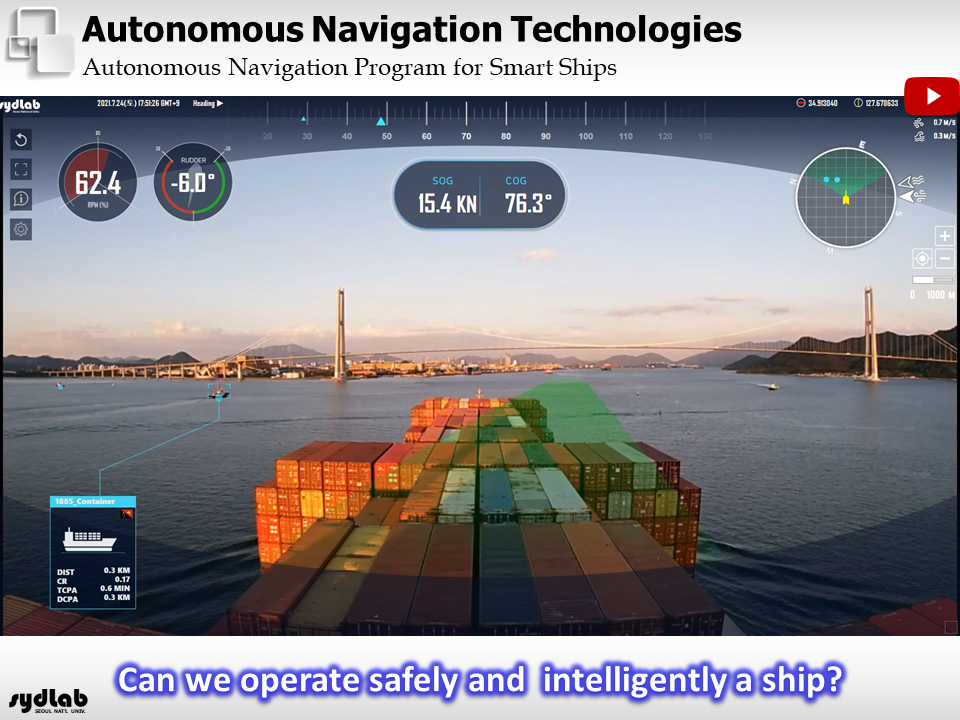
우리는 스마트 선박을 위한 자율 운항 프로그램을 개발하고 있습니다. 연구실에서 개발 중인 해상 장애물 탐지/위치 예측/추적, 다중 센서 융합, 선박 충돌 회피 등의 모든 기술이 통합된 프로그램입니다. 이 프로그램은 해양 시뮬레이션 장비와도 연동해 실행할 수 있습니다.
– 해상 장애물 탐지/위치 예측/추적 – 다중 센서 융합 – 충돌 위험도 산정 및 충돌 회피 경로 생성 – 해양 시뮬레이션 장비와의 연계
We are developing an autonomous navigation program for smart ships. This program integrates all the technologies currently under development in our lab, including maritime obstacle detection, localization, and tracking; multi-sensor fusion; and ship collision avoidance. The program can also be linked to ocean simulation facility for execution.
– Detection, position prediction, and tracking of maritime obstacles – Multi-sensor fusion – Collision risk assessment and collision-avoidance path generation – Integration with ocean simulation facility